VIS 2026VIS 2026 — Virtual Island Summit|Also: GSIS 2027GSIS 2027
Island Innovation Logo
About
Services
The Network
Events
Content Library
Contact Us

Subscribe to our newsletter. By submitting, you agree to our Privacy Policy.

Island Innovation

Island Innovation works with governments, institutions, and partners worldwide to support island-led sustainable economic development.

We Support The UN Development Goals

SDG 9: Industry, Innovation and Infrastructure
SDG 11: Sustainable Cities and Communities
SDG 12: Responsible Consumption and Production
SDG 13: Climate Action
SDG 14: Life Below Water
SDG 17: Partnerships for the Goals

Explore

AboutServicesNetworkEvents

Content

ArticlesNewsCareers

Ready to Connect?

Join the island innovation community

Get in Touch

About

  • About us
  • Case Studies
  • FAQs
  • Press
  • Careers
  • Contact

Services

  • Services Overview
  • Public & Media Relations
  • Strategic Communications

Network

  • The Island Network
  • Academic Council
  • Newsletter

Events

  • Our Events
  • Watch Past Events

Content

  • All Content Library
  • Videos
  • Articles
  • News
Privacy PolicyTerms of ServiceContactManage email preferences

© 2025 Island Innovation. All rights reserved.

    News

    Curated stories and analysis from islands and sustainability leaders worldwide.

    Filter by Core Theme

    All ThemesCircular EconomyClimate ActionConnectivity & DigitizationCulture & CommunityEnergy & TransportGreen Finance & EconomyOcean & BiodiversityPolicy & GovernanceTourism & Remote WorkWater & Food
    Showing 9 of 520 news items in Climate Action
    Kiribati’s Line Islands Mapped to Bolster Climate Resilience
    Climate ActionSeptember 17, 2026

    Kiribati’s Line Islands Mapped to Bolster Climate Resilience

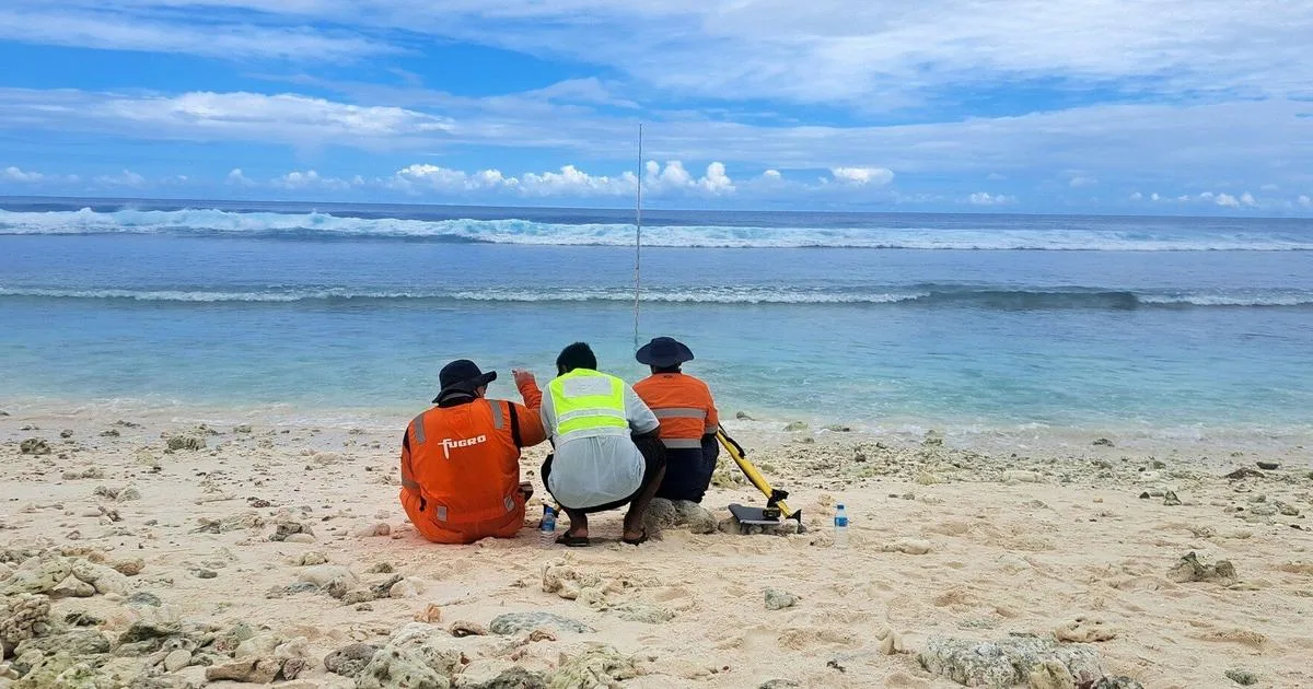
    Fugro has completed high-resolution coastal mapping and ground survey work across Kiribati's remote Line Islands, providing essential Geo-data to support climate-resilient planning, infrastructure development, and environmental management. The work was carried out in support of the Kiribati Outer Islands Resilience and Adaptation Project, known as KOIRAP, led by the Ministry of Culture and Internal Affairs and funded through the World Bank-supported KOIRAP program. The project supports the Government of Kiribati’s efforts to strengthen climate resilience and improve understanding of coastal processes, flood exposure, and environmental change across the Line Islands. Operating across the atolls of Kiritimati, Tabuaeran and Teraina, Fugro used its RAMMS® airborne LiDAR and imaging system to acquire high-resolution coastal and topographic data. The airborne survey was supported by extensive ground control activities, including survey control points, Global Navigation Satellite System observations, and tide gauge installations, helping ensure the accuracy and long-term value of the datasets. The resulting Geo-data will provide a trusted foundation for future studies, coastal resilience programs, and evidence-based decision-making across Kiribati’s Line Islands. It will help government agencies and communities better understand coastal change, assess climate-related risks, and plan for the impacts of sea-level rise. Mr. Manikaoti Timeon, Project Manager of the Kiribati Outer Island Resilience and Adaptation Project, said: “With the Government of Kiribati’s long-term aim to develop Kiritimati as a secondary economic hub to South Tarawa, we must have the necessary baseline data to ensure that our development takes adequate account of natural hazards and climate change, especially sea-level rise. The high accuracy of the LiDAR dataset collected by Fugro enables this, and will allow us to carry out a robust assessment to ensure resilience and adaptation are adequately accounted for.”

    12345678910
    Read more
    A Robot Swarm Is On a Mission to Map Greenland’s Perilous Ice Sheets
    Climate ActionSeptember 17, 2026

    A Robot Swarm Is On a Mission to Map Greenland’s Perilous Ice Sheets

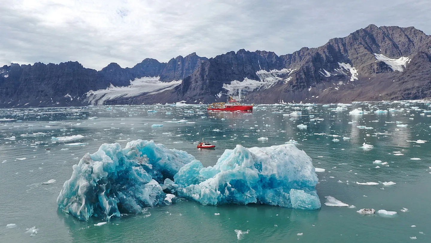
    This summer, in remote Greenland, a suite of high-tech gadgets and robots will be deployed, James Bond–like, at the treacherous points where glaciers meet the sea. Their mission: Study melting ice in never-before-seen detail. The data from the expedition, funded by the British government’s secretive new inventions agency, will feed into the latest climate models. The idea is to forecast when the ice melt will tip climate-regulating ocean currents into a shutdown, and try to develop an early warning system that would let humanity know when glaciers are changing in an alarming way. The voyage, launching on July 16, “addresses a foundational data deficit in one of the most consequential parts of the climate system,” says sea ice acoustics expert Hari Vishnu of the National University of Singapore, who isn’t involved in the work. “We cannot model what we cannot observe.” Until recently, such a mission would have been impossible. Where Greenland’s glaciers meet turbulent waters, “ice cliffs tower above the ocean surface — sometimes 30 meters high, sometimes a hundred — fracturing, collapsing and launching house-sized icebergs into the fjord with little warning,” says oceanographer Jonathan Nash of Oregon State University in Corvallis. Nash is a member of the project, which is named GIANT, for Greenland Ice sheet to AtlaNtic Tipping points from ice loss. Under the sea surface, Nash says, chaotic plumes and eddies rise and swirl. It’s difficult and dangerous for scientists to get instruments close enough to the key area of interest: the centimeters-thin boundary layer where ice meets ocean. The danger element, combined with the challenges and scale of collecting lots of different types of data from above, on and below ice all at once meant previous projects could work on only one aspect of the problem at a time, if at all. “We always wanted to create a project that could simultaneously observe and model all parts of this process,” says Paul Holland, an ice scientist at the British Antarctic Survey in Cambridge, England. So, when Holland and his colleagues saw a call for grant proposals from the U.K. government’s recently launched Advanced Research and Invention Agency, which backs high-risk projects, they jumped at it. The 20 million British pounds ($26 million) in funding comes at a time when uncrewed technology is becoming sophisticated enough to eavesdrop on ice at close range, traversing perilous waters and crumbling ice rocks without endangering researchers. “We’re in a moment where our tools have finally caught up with our questions,” says marine geophysicist Kelly Hogan of the British Antarctic Survey. “We can explore glacier-ocean interactions in ways that were unimaginable just a few years ago.” Climate models don’t account for intricacies of ice melt As Earth warms, Greenland is already losing several times more ice than it did just few decades ago. If enough freshwater from melting ice enters the ocean, it could topple vital ocean currents. One, the Atlantic Meridional Overturning Circulation, or AMOC, transports warm tropical waters northward before cooling, sinking and returning southward. An interruption of AMOC would make Europe colder and drier, and would also dramatically shift tropical monsoons, affecting agriculture and the food supply. “If the AMOC is a pot of warm, salty soup that’s flavored just right, then it’s like adding cold tap water to the pot. The Greenland icebergs ruin the soup,” says earth scientist Kristin Poinar of the University at Buffalo in New York, who is not involved with the expedition. “The AMOC relies on dense, salty ocean water to sink, and too much freshwater from icebergs will slow or stop that process.” Multiple lines of evidence suggest that the AMOC is already weakening. The actual shutdown of the current, and its impacts, would play out over decades or centuries, though there is still a lot of uncertainty. That’s in part because climate models have so far treated ice melt as a simple process — warm water arrives, heat is transferred and ice melts. They don’t account for the physical complexity of the environment where huge glaciers meet choppy seas. One such nuance is the tiny bubbles of ancient air trapped in glacier ice that are freed during melting and then rise along the ice face. They may intensify the mixing of the ice-ocean layer and drive more heat transfer. But they’ve been impossible to observe and thus to add to existing models. Though the bubbles are small, Nash says, they could have “considerable” implications for sea-level rise projections when multiplied across hundreds of glaciers. Heat transfer by such bubbles may also be one of the myriad similarly small but important drivers in iceberg calving events — when chunks of ice break off at the edge of a glacier or ice shelf and fall into the sea. Glaciers shed many icebergs into the ocean during some years and fewer in others, a phenomenon the mission’s data should help explain, Poinar says. The expedition’s planned millimeter-scale observations of phenomena such as bubbles, she says, will be “like watching a crack form in a windshield before it shatters.” The observations will feed into a climate model called the U.K. Earth System Model. It “is already a very good climate model, and it’s about to get even better,” Poinar says. The voyage “will give it an immediate upgrade, driven by brand new data from some of the most data-scarce places on Earth.” A flotilla of robots will fill in the details The mission will deploy a fleet of submarines, robots, drones and sensors from a mothership, the Royal Research Ship Sir David Attenborough, which itself is a floating laboratory. The vessel will spend much of July and August near the steep fjord glaciers of Kangerlussuaq in southeast Greenland. Next summer, measurements will take place at the Petermann glacier in Greenland’s northwest. Many of the robots are being tested in the field and tweaked on an ongoing basis to make them work as hoped, Holland says, so “reality is perhaps more experimental than you would see in [James Bond] films.” The ship will release rugged flying drones to study ice from above, at a closer range than the satellite data the team already gets. The drones are engineered to stay airborne when the weather turns hostile or when ground access collapses. The vessel’s helicopter will drop small sensors to measure changes on the surface of glaciers, terrain that is naturally booby-trapped with crevasses and ice streams. The sensors are essentially a GPS in a javelin. The javelins embed into the ice on one end and track the ice movement as the glacier melts, all while transmitting data to researchers from the antenna on the end that sits above the ice.

    Read more
    Singapore to Merge Several Outer Islands to Form New Western Island
    Climate ActionSeptember 3, 2026

    Singapore to Merge Several Outer Islands to Form New Western Island

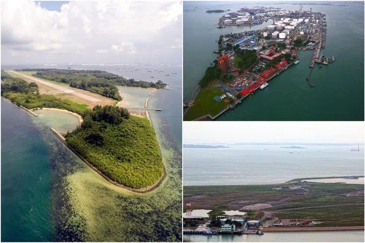
    Singapore intends to merge several southern islands to create a new “western island” in the coming decades for a new generation of industries, power generation infrastructure and defence needs. Pulau Semakau, Pulau Bukom and Pulau Sudong are among the islands that could be merged through planned land reclamation announced by Prime Minister Lawrence Wong on Aug 23 at the 2026 National Day Rally. PM Wong said the new island follows the example of Jurong Island, a global energy and chemicals hub that was formed from the reclamation of several offshore islands. That investment has delivered lasting benefits for Singapore, he added, citing Jurong Island’s role in creating jobs and anchoring important industries, making Singapore a critical node in global energy flows, and strengthening its energy security and resilience, most recently amid the disruptions in the Middle East. Said PM Wong: “Jurong Island was the result of bold decisions, careful planning and sustained investment over many decades. “Now it’s our turn to think just as boldly, and build for the next generation.” He said that every piece of land matters in Singapore, where space is needed for homes, jobs, transport and infrastructure. At the same time, the Republic cherishes green spaces, biodiversity and places with heritage and history. “Sometimes, difficult choices and trade-offs have to be made. “Where development is necessary, we study the impact carefully, make adjustments and minimise the disruption.” Nearly half of Singapore is covered in greenery, PM Wong pointed out, adding that Singapore is continuing to expand its green spaces and strengthen native biodiversity. He stressed that the Singapore way is to plan far ahead by creating new options for future generations so that they will have room to grow, while preserving what is precious about the city-state. He said: “We plan 50, 70, even 100 years ahead. We plan with every Singaporean – born and not yet born – in mind.” To create some of these new possibilities, the Government is looking to transform Singapore’s outer islands, said PM Wong. He highlighted a cluster of islands south of Jurong Island, which includes Pulau Semakau that houses Singapore’s only offshore landfill, Pulau Bukom where the nation’s first refinery still operates, and Pulau Sudong. According to a video shown at the rally, the reclamation profile for the area could also absorb Pulau Hantu, Pulau Jong and Pulau Sebarok.

    Read more
    This Pacific Island Disappeared Under Rising Seas. A New Sculpture Marking the Spot Will Morph Into a Home for Seabirds, Coral and Marine Life
    Climate ActionSeptember 3, 2026

    This Pacific Island Disappeared Under Rising Seas. A New Sculpture Marking the Spot Will Morph Into a Home for Seabirds, Coral and Marine Life

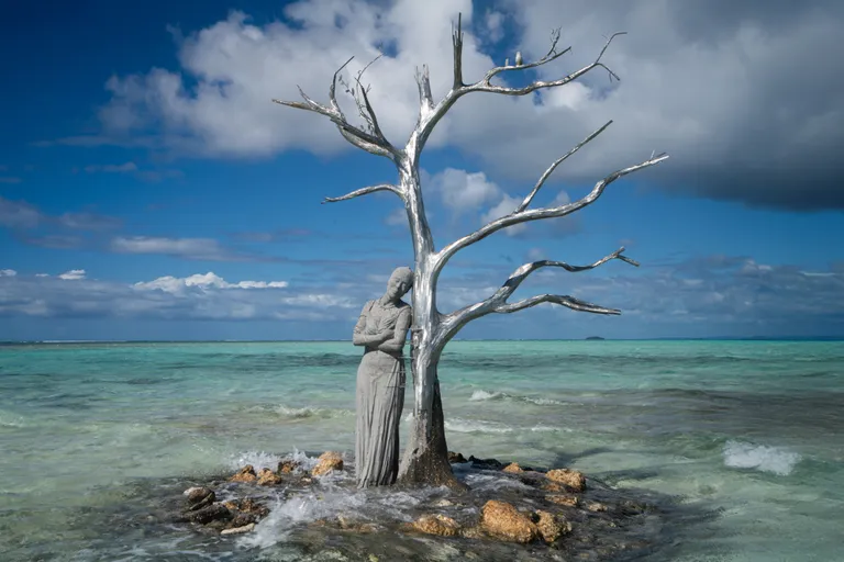
    A decade ago, rising tides in the Pacific Ocean submerged Kale, a 50,000-square-meter island in the Solomon Islands archipelago. Once home to a small community, Kale was one of the first documented islands in the world to be lost to sea-level rise, which continues to threaten the Solomon Islands. Since 2008, more than 26,000 people across the island chain have been forced to relocate from their homes due to the encroaching ocean and extreme weather, Nicola Smith and Charley Piringi reported for the Telegraph in 2023. “With its white sandy beaches, clear waters and lush forests, Kale was a jewel between the ocean and the sky,” wrote climate activist Gladys Habu Bartlett, who grew up on the Solomon Islands, in a 2020 guest blog for the International Institute for Environment and Development. “It was a much-loved spot for people living on the northwest of the Solomon Islands’ Isabel Province and a significant part of our cultural heritage.” Now, to commemorate ten years since Kale was officially lost, a marine artist installed a new sculpture in the intertidal zone where sand intermittently peeks above the waves. The Solomon Siren by British artist Jason deCaires Taylor pays homage to a lost home while also celebrating Bartlett’s environmental activism. “Modeled on Gladys, the sculpture stands as a memorial to a lost landscape and a powerful reminder of the communities already living with the impacts of climate change,” Taylor writes in an Instagram post. The sculpture portrays a life-size figure of Bartlett—who has been recognized internationally for her work to advance gender equity and environmental awareness in the Pacific—resting against a tree that represents the former island’s diverse vegetation and natural resources. The artwork is made from pH-neutral cement and biochar, which creates a porous surface “suitable for marine colonization” by algae, corals and invertebrates, My Modern Met’s Sage Helene reports. Meanwhile, the tree’s branches offer a resting place for seabirds. The sculpture has markings tracking sea level rise in the area in 2006, 2016 and 2026, as well as projected marks for 2036 and 2046 based on climate models. Per a recent United Nations report, global sea levels are rising today at twice the rate of a decade ago. “Year after year, we watched the sea rise. We watched our homeland disappear,” Bartlett says in a video accompanying the sculpture’s debut. “I chose to share our story, and this sculpture is a deeply meaningful part of it. What happened is a warning, not only for us, but for the world.” The sculpture is the latest in Taylor’s ongoing “Siren” series responding to marine ecosystems. His Sirens of Sewage sculpture in Whitstable, England, sought to raise awareness about water companies’ release of untreated sewage along the coast. And his Ocean Siren sculpture off the coast of Australia changes color to reflect the real-time temperature of the Great Barrier Reef, where warming water leads to coral bleaching.

    Read more
    Scientists X-Rayed Ancient Penguin Bones From Remote Antarctic Island. Here’s Why.
    Climate ActionAugust 27, 2026

    Scientists X-Rayed Ancient Penguin Bones From Remote Antarctic Island. Here’s Why.

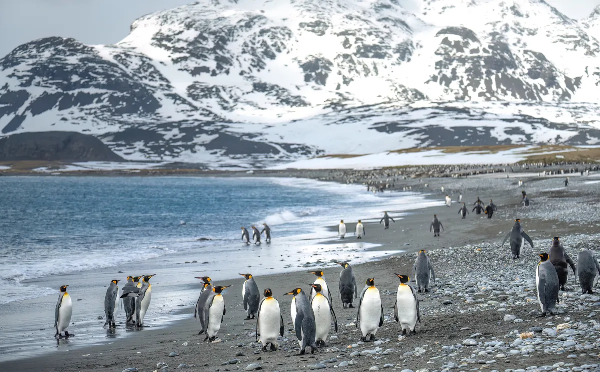
    A study of penguin fossils, conducted by researchers from China University of Geosciences in Beijing, has revealed how ancient bones can offer a glimpse into climate change from millions of years ago. This study, published in the journal Fossil Record, is the first use of vertebrate fossils to reconstruct ancient climate change, linking penguin bone chemistry to Antarctica’s environmental history. The penguin fossils, found on Seymour Island (located around the tip of Graham Land on the Antarctic Peninsula), date back to the Eocene epoch, which spanned approximately 34-56 million years ago. Seymour Island provides insight into a significant chapter of Earth’s history of climate change. As the island’s rock layers stack up in a mostly unbroken sequence, they offer a unique look into major geodynamic changes, including the initial growth of the Antarctic ice sheet and the opening of Drake Passage. This makes Seymour Island a rare natural laboratory for tracing how climate conditions on our planet shifted over millions of years. Although scientists traditionally relied on whole-rock geochemical approaches to study this area, this new study offers a fresh source of environmental data. “Penguins are among the most iconic animals of Antarctica and represent one of the most distinctive groups of birds, having completely lost the ability to fly and instead using their flipper-like wings for swimming,” say the research team. “Seymour Island preserves one of the world’s richest and most stratigraphically continuous records of Eocene penguin fossils. These fossils span an important interval of Antarctic climate evolution, from the relatively warm and humid conditions of the early Eocene to the cooler climate of the middle and late Eocene.” The fossil chemistry To analyse the fossils, the scientists used a technique called micro-X-ray fluorescence mapping, which allowed them to map chemical elements across the surface of the bones. The analysis found that the oldest fossils, from around 54-55 million years ago, had much higher levels of titanium, silicon and potassium. These chemical patterns point to intense rock weathering – a sign that the climate of that time was warm and humid, causing more erosion and runoff into the area where the penguins died and their bones fossilised. “Based on the statigraphic, sedimentological and paleoclimatic evidence, we interpret this pattern as being consistent with stronger continental weathering and terrestrial material input under the warm and humid conditions of the early Eocene,” adds the research team. The scanning method also detected iron, manganese and sulphur patterns trapped within the bones – reflecting local chemical changes in the marine sediment as the fossils were buried over millions of years.

    Read more
    Hawaii Could See Its First Hurricane Landfall in Decades as Lala Strengthens
    Climate ActionAugust 20, 2026

    Hawaii Could See Its First Hurricane Landfall in Decades as Lala Strengthens

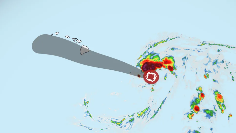
    Hawaii is bracing for a potential hurricane strike this weekend after Tropical Storm Lala’s forecast track shifted north, bringing the strengthening storm — and its heavy rain, damaging winds and dangerous surf — close to the Big Island. A hurricane warning is in effect for Hawaii County, meaning hurricane conditions are expected somewhere on the Big Island by this weekend. A tropical storm warning was issued for Maui County Friday morning, including the islands of Maui, Lanai, Molokai and Kahoolawe. A tropical storm watch was also issued for Oahu and Kauai counties. Lala had sustained winds of 65 mph Friday evening as it moved west-northwest about 260 miles southeast of Hilo, according to the National Hurricane Center. The latest forecast takes Lala near the Big Island on Saturday, raising the possibility of a rare hurricane landfall there. Even a slight shift in its path could determine whether the storm’s center crosses the island or narrowly passes to its south. Regardless, Lala will track close enough to bring strong winds and heavy rain onshore. Hawaii Gov. Josh Green declared a statewide emergency Thursday, allowing officials to activate the National Guard and access emergency funding as the state prepares for Lala. Ahead of the storm, officials in Maui County – where a flood watch is in effect through Sunday – identified temporary evacuation points residents could flee to if conditions worsen. “For Maui County, our main concerns are flash flooding, rapidly rising water in flood-prone areas, and power outages that could leave residents without electricity during the storm,” Mayor Richard Bissen said. “Secure your property, stock up on essentials, prepare for possible power outages, and check on kūpuna (elders), neighbors and loved ones.” Confidence in the exact track should improve through Friday, but there could still be changes as the storm approaches the islands and interacts with land, which can cause its center to wobble.

    Read more
    Greenland Glacier Break Creates New Ice Island
    Climate ActionAugust 20, 2026

    Greenland Glacier Break Creates New Ice Island

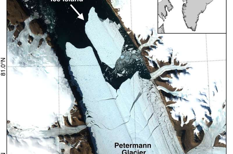
    An international research team partly led by the University of Ottawa reports that Petermann Glacier in northwest Greenland calved a 76.4 km² (29.5 square miles) ice island on Aug. 4, 2026, marking the glacier's largest loss of floating ice since 2012 and the largest Arctic calving event since 2020. The newly formed tabular iceberg detached from the glacier's floating ice tongue and is estimated to be up to 150 meters (492 feet) thick. With a surface area roughly comparable to Manhattan Island, the ice island offers scientists a rare opportunity to study how large Arctic ice masses form, drift and break apart over time. The event was detected by Adam Garbo, a doctoral student in glaciology at uOttawa's Department of Geography, Environment and Geomatics, as part of ongoing collaborations among the University of Ottawa, the University of Stirling, Environment and Climate Change Canada, Lancaster University and the University of Leeds. Years of monitoring helped researchers anticipate the break The calving event was detected through long-term satellite monitoring that has tracked changes at Petermann Glacier since 2019. Researchers have been following the glacier's floating ice tongue, documenting the growth of fractures and monitoring signs of instability over several years. "Petermann Glacier has long been one of Greenland's largest remaining ice tongues," says Garbo. "We've anticipated this break for years, and seeing it finally happen is remarkable." Satellite imagery from the European Space Agency's Sentinel-1 mission showed clear deterioration along the centerline of the ice tongue on Aug. 3. By 20:00 UTC on Aug. 4, the new ice island had detached from the eastern side of the glacier.

    Read more
    How Is Climate Change Shaping Tropical Storm Lala?
    Climate ActionAugust 20, 2026

    How Is Climate Change Shaping Tropical Storm Lala?

    Researchers used to believe that Hawaiʻi island acted “like a rock in the stream,” and the winds controlling the movement of tropical storms had to go around it, according to retired University of Hawaiʻi professor Tom Giambelluca, who now oversees the islands’ Mesonet System of weather stations. While the island’s geography – with its 13,000-foot central mountains – does play a key role in protecting parts of the island, the reasons large storms have typically been broken up and slowed before they hit Hawaiʻi are varied and complex. This summer’s supercharged El Niño is largely what’s fueling Tropical Storm Lala, which is expected on Saturday to become the first hurricane to make landfall in Hawai‘i since Iniki in 1992. But scientists say residents should be ready for more storms in the years ahead as the effects of a warming planet take hold in the islands. “I often tell students that El Niño is like a practice run for climate change,” said Alison Nugent, an associate professor at the UH Department of Atmospheric Science, pointing at how climate change is likely to bring more warm temperatures even when the current El Niño cycle is over. In the past, relatively cool ocean temperatures and wind shear — or wind that comes from other directions and disrupts the storm — have both historically been important factors in preventing storms from hitting the islands at hurricane strength. A tropical storm becomes a Category 1 hurricane when winds reach 74-95 miles per hour. Now, as meteorologists have forecast Lala increasing in strength instead of dissipating like the vast majority of storms have in recent decades, it’s raising questions about the impact of climate change. Warmer ocean temperatures are definitely playing a role, Nugent said. Hurricanes get their energy from convection, or latent heat. “When you go from a high-energy state of vapor to a lower energy state of liquid, you release heat, and that heat is what fuels hurricanes,” she said. “With climate change, you have warmer oceans, and therefore the potential to get stronger storms.” Three of the five named storms that have made landfall in Hawai‘i over the last 67 years — Hurricane Dot in 1959, Hurricane Iniki in 1992, Tropical Storm Iselle in 2014, Tropical Storm Darby in 2016 and Tropical Storm Olivia in 2018 — have occurred in the last decade. Climate modeling done in 2016 predicted a significant rise in the number of hurricanes near Hawaiʻi in the coming decades. This year, the warmer-than-usual ocean temperature is playing an important role. If the ocean is below 79 degrees Fahrenheit, a hurricane doesn’t form. If the surface of the ocean hits 80 degrees, it’s a different story. On Thursday, the ocean surface to the south of the islands was between 80.6 and 82.4 degrees Fahrenheit. Exactly how climate change is fueling Lala isn’t entirely clear, however. That’s in part because El Niño — the ocean’s natural warming pattern, which occurs every four to seven years — is also causing significantly warmer temperatures this year. And while some scientists say there’s clear evidence that the climate’s overall warming patterns are supercharging El Niño, that’s still being debated within the scientific community. “The relationship between El Niño and climate change is not well-documented or understood,” said Steven Businger, a professor and former chair of UH’s Atmospheric Sciences Department.

    Read more
    Why Maritime Decarbonisation is the Caribbean’s Next Climate Battleground
    Climate ActionJuly 30, 2026

    Why Maritime Decarbonisation is the Caribbean’s Next Climate Battleground

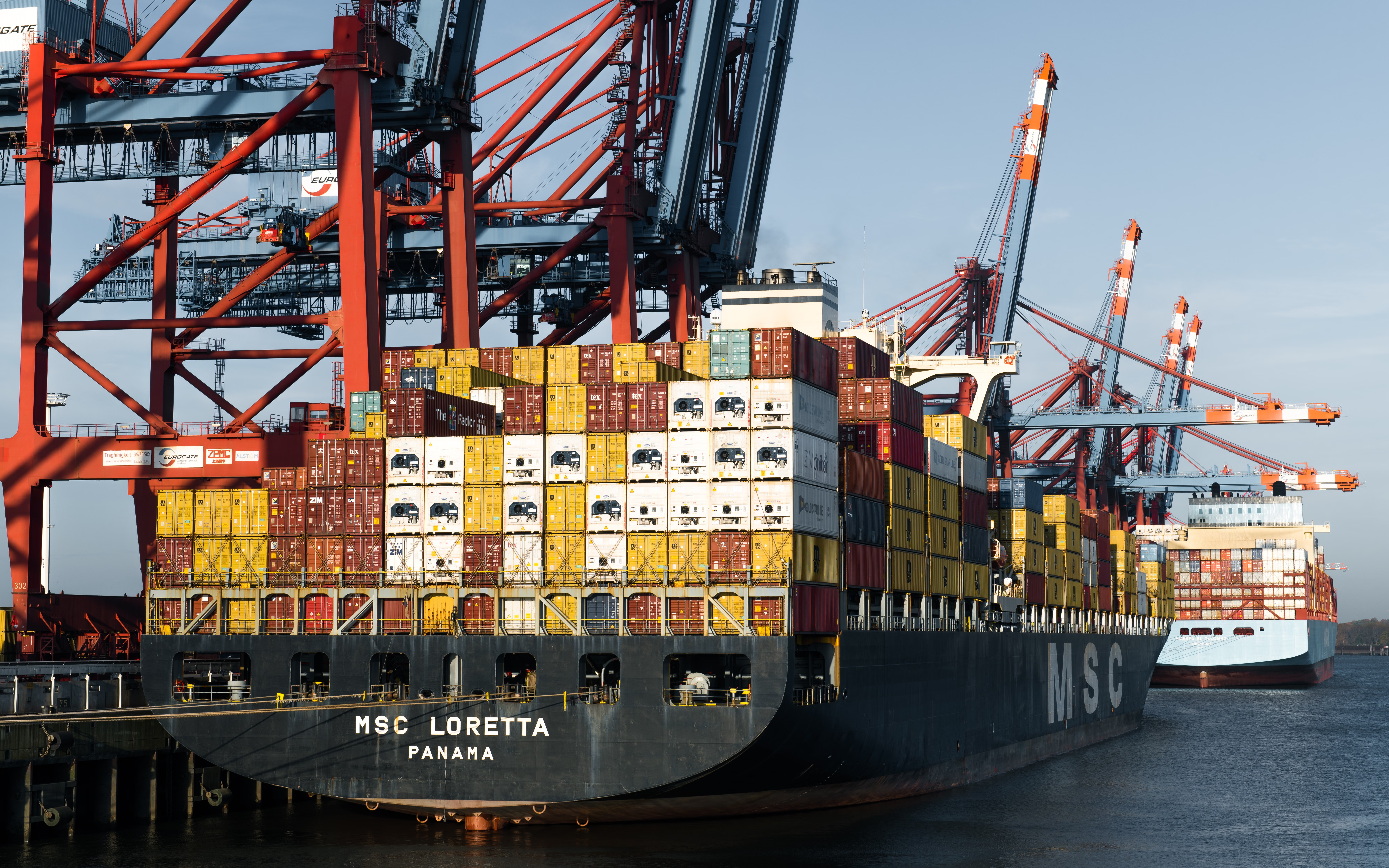
    For Caribbean Small Island Developing States, decarbonising shipping is a critical economic and climate challenge. The region depends on maritime transport for 80% to 90% of imported food and hosts a large share of global cruise traffic, so poorly designed international measures could raise costs and threaten food security. The University of the West Indies Caribbean Shipping Lanes initiative is building the technical capacity, training and regional coordination needed for Caribbean countries to shape fairer global shipping rules and pursue a resilient low-carbon maritime economy.

    Read more